
Welcome to the public footpaths of Ash. These five walks include parts of the neighbouring parishes of Woodnesborough, Staple and Preston. Ash Parish covers about ten square miles and is one of the largest in Kent. Within its boundaries are over 100 miles of footpaths.
Ash is situated 15km (9 miles) east of Canterbury and 3.5km (2 miles) west of Sandwich.
Much of the land around Ash is arable and the ground is often very muddy but the countryside is quite flat and the walks are fairly easy. Where roads form part of the walks, traffic is fairly light but please take sensible precautions. Walk facing the oncoming traffic unless it is safer to approach bends on the opposite side to oncoming traffic.
There is a sixth walk around the historic village of Ash that highlights historic buildings of interest.
The Orchards

Length: 7.3 kms. No stiles.
The Ash By-pass (A257) was built in 1993. This relieved the village of heavy traffic on what was said to to be the narrowest ‘A’ road in the country.
The Orchards are an especially fine sight at spring time with the trees in blossom. Fruit trees of various sizes will be seen. The more recent ones are planted very close and not intended to grow to a large size. This allows easier picking and good cropping.
There are two Hall Houses on this route. Paramour Grange containing murals depicting verses from an Elizabethan prayer book and Manor House at Lower Weddington with fine timber framing exposed internally.
For details of the walk that you can download please go to Orchards Walk.
Ash to Richborough

Length 12 km. Stiles: 5 The full walk is long and you should take refreshments.
What is now known as Richborough Roman Fort is the site and remains of about 400 years of Roman occupation.
The fort is open to the public and is owned by English Heritage. Click here to go to their website to see full details of visiting arrangements. The fort is closed between 15 November 2021 to summer 2022 while work is being carried out to deliver the Richborough Gateway to Britannia project.
This walk can be done from Ash Village as a circular walk or a short version can be done around the fort by leaving your car at the site and following the public rights of way around the outside of the fort.
For details of the walk that you can download please go to Ash to Richborough Walk
Ash to Staple

Length 7km. There are two stiles to climb. Circular walk starting at the Ash Car Park on The Street, opposite Chequer Lane.
This is a gentle but long walk across fields, with short walks along the rural lanes in Staple. The extension of the East Kent Light Railway from Eastry to Wingham Colliery was completed in late 1912. Passenger services began in 1916 and were withdrawn in 1948. The station was very crude, a single platform with a small wooden shelter. The line was lifted in 1954 and most signs of its existence have disappeared. The walk follows the line of the railway from Ten Acres field across to the Durlock Road.
Ten Acres is an open managed field brought by the Jack Foat Trust for the use by the people of Ash. Off The Street are two other fields also owned by the Jack Foat Trust (Street End Field).
It is thought that Durlock Stream may derive its name from ‘Dur’ – the old German for water.
Staple’s Church (St James) has an attractive Lych gate and an one handed clock in its tower. At Barnsole, there is the attractive Gander Court and the Black Pig pub which if it is open is worth a look with its beamed bars and a secluded garden.
After crossing Fleming Road, there are good views of Ash and Woodnesborough Church on the higher ground to the right. Both Ash and Woodnesborough Church Towers were once navigational points for ships in the Channel.
On the return walk to Ash Moat Farm House dating from the 16th century can be seen. Coming up to St Nicholas Church there is Chapel Cottage, formerly a Nonconformist chapel.
St Nicholas Church is a Grade 1* listed building and is also notable for the brasses in the church.
For details of the walk that you can download please go to Ash to Staple Walk.
Ash to Westmarsh
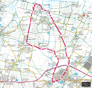
Length 8.8 km – Circular from Ash Village OR Circular from Westmarsh – length 6.75 km
One walks start and finishes from the Ash Village Centre Car Park at The Street and is shown on the map above. The other is a shorter walk starting and finishing in Westmarsh. This is a low lying hamlet at the north of the parish. It was at or near sea level in Roman times, with the Ash Levels now drained and being used for summer grazing and some cropping.
There are a number of orchards that make a lovely walk in spring with the fruit tree blossom.
There are three Hall Houses on these walks.
Santon Farm was probably a Hall House with an interesting building behind it having a crow-stepped gable – a simpler and earlier form of Dutch gable.
Uphousden, another Hall House dating from before 1400 with a Dutch gable to the south end which can be seen over the hedge.
Wingham Barton Manor is just south of the Westmarsh route. Parts of this house may originate from the 13th century but it mainly dates from the 15th century. It was originally associated with the College of Canons at Wingham.
Ware Court is a large Victorian vicarage for this small hamlet which had its own far smaller church.
For details of the walk that you can download please go to Westmarsh Walks.
Ash to Marshborough
Length: 7 kms. Stiles: 2
This circular walk takes you into the parish of Woodnesborough. There is a section of this walk where the path is very uneven and which becomes waterlogged after heavy rain.
There are a number of points of interest. Toll Cottage is an early 19th century house that used to serve the turnpike road to Sandwich. The Street End Field is an open green space purchased by the Jack Foat Trust for the people of Ash.
Coombe Lane Cottage has typical Dutch gables. Many influences of this Dutch influence can be seen in this area.
Christian Court is a good example of a period farmhouse.
Marshborough Farm is an lovely example of an old farmyard with an enormous thatched aisled barn and oast house.
Goss Hall is a 17th century farmhouse and farmyard with an aisled 16th century barn and 17th to 19th century barn and cow house.
Hills Court – only a small cottage and the remains of the old walls now exist on the site of one of Ash’s former Manor Houses.
For details of the walk that you can download please go to Ash to Marshborough.
Historic Ash Village

Length: 1.45 km.
Most of this walk is able to be done on public pavements.
It starts at Guilton and finishes along Sandwich Road. It highlights some of the many buildings of interest and gives a glimpse into the history of part of the village of Ash including Guilton.
Photos and information about many of these buildings are held at the Ash Heritage Centre at the Ash Village Hall, Queens Road, Ash CT3 2BG. It is open to the public on most Saturday mornings from 10am to 12 noon. For more information go to the Ash Heritage Centre website.
There is a public car park to the rear of the hall, with 2 electric vehicle charge points available.
For details of the walk that you can download please go to Ash Village Historic Walk.
Hall Houses
You will see many Hall Houses from the footpath walks. These were built mainly in the 14th and 15th centuries for yeomen farmers and their workers. These houses consisted of a large hall which extended to full height, containing an open hearth from which the smoke escaped through the roof. Windows were unglazed and had shutters.
Normally two storey sections were built at one or both ends of the hall. At one end on the ground floor were the buttery and pantry and at the other a parlour. On the first floor were the chamber and the solar.
From the 16th century onwards Hall Houses were usually ‘modernised’ by the provision of brick fireplaces and chimneys, the addition of a first floor within the hall and cladding of the timber frame in brickwork, plaster or tile hanging.
From the outside the identity of the Hall Houses is not always apparent but their proportions normally give a clue.
Use of Public Rights of Way
Footpaths, bridleways and roads used as public paths are signposted from roads and are indicated by waymarking yellow arrows at various points.
FOLLOW THE COUNTRYSIDE CODE
- Keep to the path except where it is obstructed
- Control dogs keeping them to the path at all times.
- Where crossing fields with stock in them, you must keep your dog on a lead.
- Close all gates and take your litter home with you
The Landowner has a duty to allow you free passage on footpaths and keep the paths free from crop growth.
If you find a problem on a Public Right of Way, please report it on the Kent County Council Public Rights of Way website by clicking here.